
Latest Update
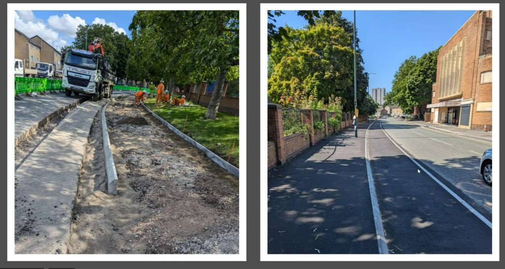
Works to construct the new cycle lane began on Monday 10 July, 2023. This follows in-person and online consultation events including progression through the Traffic Regulation Order process. The scheme is expected to be complete by summer 2024.
Works on cycle lane are now complete (early September 2024) with a snagging process underway until the end of September.

Background
As part of the Active Travel Fund, the Government has worked with Nottingham City Council to develop a Local Cycling and Walking Infrastructure Plan, which sets out our long-term approach to developing comprehensive local cycling and walking networks across the city.
St Ann’s Well Road has been identified as one of the priority routes as it serves the north and east of the City where cycling provision is currently lacking compared to other areas.
Improvements to cycling provision along St Ann’s Well Road were made during the Covid-19 pandemic, recognising the significant rise in the number of cycling journeys during that time. This scheme aims to build on the changes that were introduced and to provide a step change in cycle infrastructure provision along the St Ann’s Well Road corridor.
Benefits of the Improvements
The St Ann’s Well Road Cycling Corridor scheme is expected to deliver a number of benefits including:
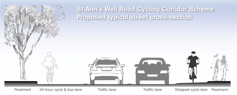
- Dedicated stepped cycle lane to enable safer cycling
- Re-alignment of junctions and upgrade of traffic calming features to reduce vehicle speeds
- Support a longer term increase in active travel mode share by complementing the Local Cycling and Walking Infrastructure Plan
- Improve mobility as people return to employment/education and need to access services following the COVID 19 pandemic
- Contribute to improving air quality and meeting Nottingham’s 2028 Carbon Neutral objective.
Funding Information
Active Travel England (ATE) is the government’s executive agency responsible for making walking, wheeling and cycling the preferred choice for everyone to get around in England.
This scheme is being delivered using grant funding from ATE’s ‘Active Travel Fund’ (ATF) which is a capital investment programme set up to:
- Encourage 50% of short urban trips in England to be walked, wheeled or cycled by 2030
- Increase active travel from 41% in 2018 to 46% of short urban trips by 2025
- Increase walking to 365 stages per person per year by 2025
- Increase cycling from 0.8 billion stages in 2013 to 1.6 billion stages in 2025
- Promote 55% of primary school-aged children to walk to school by 2025
- Align investment with Gear Change and wider government objectives, including local growth and productivity, tackling public health issues, decarbonisation, levelling up and cost of living challenges
- Increase participation in active travel amongst underrepresented groups
More details about the ATF programme can be found on Active Travel England’s website here.
The Scheme
As shown in the following drawings, in order to improve the cycling provision along this corridor, it will be necessary to make a few changes to the existing parking restrictions and traffic calming features along St Ann’s Well Road including:
- The removal of the RingGo (P&D) parking bay opposite the Curzon Street junction and its replacement with a new RingGo (P&D) bay on Lamartine Street, operational 8am-10pm
- The introduction of a ‘no waiting at any time / no loading Mon-Fri 7.30am – 9.30am’ restriction on the entire eastern / southern side of St Ann’s Well Road, between its junctions with King Edward Street / Bath Street and Ransom Road
- The introduction of a ‘no waiting at any time / no loading Mon-Fri 4pm – 6pm’ restriction on the entire western / northern side of St Ann’s Well Road, between its junctions with King Edward Street / Bath Street and Ransom Road, with the exception of:
A 2-hour (no return within 1 hour) limited waiting bay operational 8am – 8pm, Monday to Saturday adjacent to no’s 259-265.
A 2-hour bay currently exists at this location, however, we are proposing to shorten the bay to allow the cycle facilities to continue along the more narrow sections of St Ann’s Well Road. The restrictions will also be relaxed on Sundays, allowing motorists to park in this bay for as long as necessary.
- The removal of all ‘priority give-way’ traffic calming features and their replacement with 75mm (max) round-top road humps at 11 locations along the St Ann’s Well Road corridor
- A new raised plateau and zebra crossing adjacent to Hedderley Walk (replacing the priority-give way crossing currently at this location)
- Improved raised plateau zebra crossings adjacent to King Edward Street, Robin Hood Chase and the Luther Close bus stop (SA12).
And in addition, a new 10-minute parking / loading bay (no return within 30 minutes) on Shelton Street for the use of nearby businesses
A proposal was put forward to close the southernmost Northumberland Close Spur Road / St Ann’s Well Road junction however following comments received during the consultations, this is no longer being progressed.
Maps of the planned scheme are below – because of the length of the proposed scheme, they are broken up into sections. Each map has an image and a pdf that can be opened and zoomed into.
Section A:

St Ann’s Cycling Corridor Plan Section A
Section B
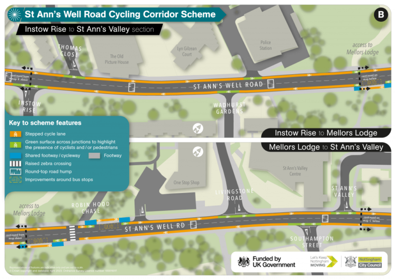
St Ann’s Well Road – Cycling Corridor Consultation Plan – Section ‘B’
Section C

St Ann’s Well Road – Cycling Corridor Consultation Plan – Section ‘C’
![]()